Test Mining the Deep-Sea

Title: Environmental Impact Statement
“Prepared by GSR NV, in collaboration with RBINS, for submission to the ISA Environmental Management Plan.”
Report Length: 337 pages
Disclaimer: This report was finalized in April 2018. Technical outcomes of the 2019 trial and regulatory developments since then are not included here. Readers are encouraged to consult updated ISA documents and post-trial reports for current status assessments.
BLUF: GSR’s Environmental Impact Statement for the Patania II trial in the CCFZ outlines a tightly scoped, technology-validation campaign aiming to assess the environmental footprint of early-stage nodule collection systems while advancing monitoring strategies in collaboration with a large European scientific consortium. Though limited in duration and area, the trial’s findings are expected to shape future commercial-scale environmental assessments and ISA regulatory frameworks.
The EIS documents a planned 4-day test of the “Patania II” vehicle in a 0.1 km² area of the deep Pacific Ocean at ~4,400 m depth.
The project is a hybrid venture between GSR’s ProCat#2 program, which focuses on the technical feasibility of nodule harvesting, and the JPI-O MiningImpact 2 consortium, which focuses on understanding and mitigating environmental impacts.
While the engineering trial aims to test maneuverability, nodule pick-up efficiency, and system durability under actual seafloor conditions, the environmental component integrates field-based research on sediment plumes, benthic disturbance, and biological resilience.
The data generated will not only inform future GSR operations but also contribute to ISA rulemaking and best practices for the broader deep-sea mining industry.
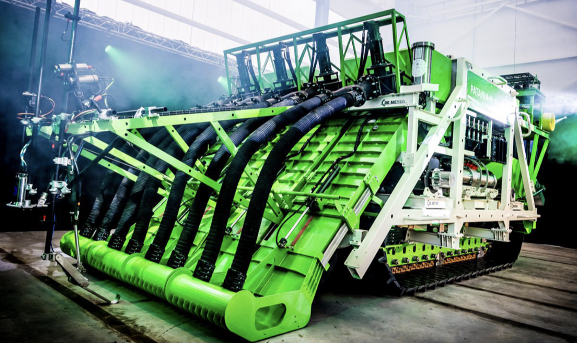
Patania II
Patania II is described as a ~4 m wide, 12 m long tracked vehicle, weighing 35 tons in air. It integrates four major systems:
- A hydraulic nodule collection head that hovers above the seabed to minimize sediment disturbance.
- A tracked propulsion system designed for maneuverability on soft abyssal sediments.
- An onboard separation and dumping system, as there is no riser to transport nodules to the surface.
- Subsystems including hydraulics, telemetry, and buoyancy controls.
This is not a commercial-scale unit but rather a “pre-prototype,” purpose-built for proof-of-concept testing under real-world conditions. Laboratory trials and Computational Fluid Dynamics (CFD) modeling underpinned the design.
Trial Design
The trials are set in the B4 block of GSR’s ISA contract area, specifically in a sub-zone called B4S03, selected for its high nodule abundance and flat topography. Impact zones are tightly delineated:
- Impact Reference Zone (IRZ): Area of direct nodule removal.
- Plume Impact Reference Zone (PIRZ): Area influenced by sediment plumes.
- Control Reference Zone (CRZ): ~11 km from IRZ, used as a baseline for unimpacted conditions.
- Resource modeling estimated nodule coverage between 12 - 24 kg/m², with the highest confidence zones making up 73% of the minable area.
Sediment Plume Modeling
- A multi-layer modeling effort simulates sediment plume behavior:
- Near-field CFD modeling tracks dispersion within 200 m of the vehicle.
- Far-field dispersion modeling suggests that sediment with >1 mm deposition could settle within 500 - 750 m, and finer particles (0.1 mm deposition) could reach ~5 km.
- Concentrations of 10 mg/l may extend ~1 km from the source, with 0.1 mg/l reaching up to 12 km under strong currents.
- The plume is mostly confined to the bottom 25 m of the water column, with negligible vertical mixing due to steep density gradients, minimizing exposure to midwater fauna.
Identified Environmental Impacts
- The EIS outlines potential impacts under normal and accidental conditions, supported by a detailed risk matrix (Attachment A). Main categories include:
- Seafloor disturbance and compaction, resulting in habitat loss and potential faunal mortality.
- Plume-related effects like smothering, trace metal release, and changes to water clarity.
- Acoustic and light disturbance, though expected to be minor and spatially limited.
- Hazards from hydraulic fluid leaks, mitigated via the use of biodegradable oil.
- Entanglement and noise effects in the water column during ascent/descent phases.
Mitigation Strategy
- GSR outlines a suite of mitigation measures embedded in design and operations:
- Use of caterpillar tracks for reduced sediment displacement.
- Hovering collector head to minimize substrate penetration.
- Biodegradable oils and low-noise equipment.
- Pre-deployment checklists, and staged light/sound activation to minimize wildlife disturbance.
- The JPI-O consortium, operating independently aboard the RV Sonne, will execute a coordinated monitoring program covering:
- Benthic biodiversity, food web impacts, and biogeochemical shifts.
- Plume behavior through time-series sampling.
- Archiving of samples and data in repositories like PANGAEA.
Regulatory Framework
The activity is governed under UNCLOS and the ISA’s 1994 Implementing Agreement. While ISA “Recommendations” guide EIAs during the exploration phase, there is no binding regulation.
GSR has followed best practices from analogous sectors (e.g., offshore dredging) and structured its EIS using elements from the ISA’s 2017 draft exploitation regulations.
The trial’s limited scope (0.1 km² for 4 days) exempts it from full industrial EIA templates; however, the transparency and rigor of the study position it as a foundational precedent for future regulatory development.


